
By 1806, the land that is now North Crosby and Newboro Ward had been surveyed and divided up into 10 concessions by 27 lots. It was called North Crosby Township. What became Salem was on the western edge, near the boundary with what is now Frontenac County. It saw its first settlers in the late 1820s. One of them was Levi Judd who moved onto lot 11, on the 9th concession.1
The original log school in Salem was replaced in about 1856 by a stone building. It was south and across Devil’s Lake Road from the stone church, which was built at the same time, and that remains at the corner of Westport Road (CR12) and Devil’s Lake Road. This stone school was hard to heat, so after attempts to address the problem, it was finally replaced in 1914 by a redbrick school. Locals called it “Unity School” since it stood near the border between Frontenac and Leeds Counties and drew students from both counties.2 Today the red brick has been stuccoed over and painted yellow, and it is a private residence.
The first school in North Crosby Ward was a log structure built in the 1830s or 40s, on the north side of the Westport Road, not far outside Salem. By 1848 this school had eighty students, half boys and half girls. The last teacher was Miss Matilda Jane Hamilton, in 1868, when the log school was replaced by the stone “Noah Halladay School.”
Noah Halladay was a blacksmith who purchased an acreage on the Ninth Concession in 1837 where he farmed and ran his blacksmith shop. The stone fences on his property are a testament to the rocky terrain in this area, and the hard work of farming in the Canadian Shield. The new Halladay School was built on a corner of this property, and remains today at the corner of Westport Road and Concession Road 9. It is a one-and-a-half storey, three-bay, stone structure with a large, windowed vestibule, that is now a private home.
Alfred Palmer, whose farm was further east on Westport Road, was a fortunate beneficiary of the new Halladay School construction: the old log school was moved to his property and the teacher, Miss Hamilton, agreed to marry him.3 The Palmer farm operates to this day as Palmer Berry Farm.
Between the Halladay School and Salem, on Westport Road, there remain three houses from the mid-19th century: the Samuel Ripley house, the Alba Taggart house, and the William Ewing house. Each is a one-and-a-half storey, stone house and each retains its original appearance. Indeed, by 1861, the Salem area had a relatively prosperous feel to it, with five stone houses, all built by Scottish mason, Peter Ewing.4 Other early stone, wood-frame and red brick houses may also be seen in the area around Salem.
In 1893, R. Bolton and B. Derbyshire were given the contract to build the cheese factory a quarter kilometre south of the Salem School, for D. P. Alguire5 and by March 28 of that year Mr. Alguire had “a number of men engaged building [the] cheese factory at Salem.” By 1929, Sam McCann Jr. operated the Salem Cheese Factory along with five other cheese factories in the area, namely the Ardmore, Blair/Centreville, Mountain View, Ontario and Westport Cheese Factories.
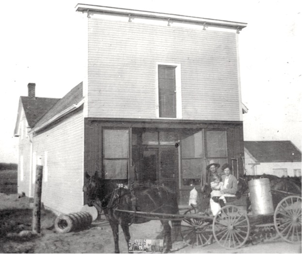 Salem Grocery Store with Clarence and Birdie Saunders and son Edgar in front, Salem Ontario, 1909.
Shelva Saunders Hutchings photograph collection.The Salem Cheese Factory was the largest in the area, producing close to 100,000 lbs of cheese every year. Forty-pound veneer boxes of cheese were delivered by the wagon-load every Friday for shipment. Initially the cheese was shipped on ice cut from Upper Rideau Lake, to Kingston in barges through the Rideau Canal system. Later it was shipped in refrigerated rail cars.6
Salem Church was Wesleyan Methodist from its origins in the mid-1800s, and was part of a circuit that included churches in Burridge, Westport, Newboro, Singleton’s Corners (later Crosby) and Forfar. In 1925, the Methodists, Congregationalists and most of the Presbyterians in Canada amalgamated to form the United Church of Canada, including the church in Salem. But in the late 1960s, the original circuit was reduced by half, retaining only the churches in Burridge, Westport and Newboro. The churches in Salem, Crosby and Forfar closed at that time.7 According to one resident, who attended the church in Salem in the mid-1900s, services took place on Sunday afternoons, since the minister was shared by the circuit, and the women and men sat on opposite sides of the aisle from each other.
Across the road from the church there was formerly a grocery store. This store, along with the cheese factory, the Unity School and the church, formed a busy community gathering spot, at what is now a quiet, rural crossroads.8
By Allison Margot Smith
Municipal Heritage Advisory Committee, Township of Rideau Lakes.
1 Neil A. Patterson, History of the Township of North Crosby and Westport (Westport, ON: Township of Rideau Lakes and Municipality of Westport, 2006), 3, 9, 42–43.
2 Municipal Heritage Advisory Committee (MHAC), The Heritage Map of the Township of Rideau Lakes and the Village of Westport (Township of Rideau Lakes, April 27, 2018).
3 MHAC, “Driving Tours - Crosby to Salem,” Township of Rideau Lakes, 2019, http://www.rideaulakes.ca/explore/trails-tours/driving-tours/; Patterson, History of the Township of North Crosby and Westport, 13–14, 22.
4 “Census of Canada, 1871, South Leeds, Ontario,” 1871, Library and Archives Canada, https://www.bac-lac.gc.ca/eng/census/1871/Pages/results.aspx?k=Leeds+South+AND+cnsProvinceCode%3a%22ON%22; “Crosby to Salem Historical Driving Tour,” Frontenac Arch Biosphere, accessed July 27, 2020, https://www.frontenacarchbiosphere.ca/explore/tours/heritage-walking-tours/crosby-to-salem-historical-driving-tour; MHAC, “Driving Tours - Crosby to Salem”; Patterson, History of the Township of North Crosby and Westport, 38.
5 Staff Writer, “Local Summary,” Athens Reporter and County of Leeds Advertiser, March 7, 1893, 4, Lakes and Islands, Times Past: The Shared Digital Histories of Rideau Lakes & Leeds and the Thousand Islands.
6 Patterson, History of the Township of North Crosby and Westport, 66–67.
7 Ida Hutchings, “Focus on Newboro: Village History,” Northern Leeds Lantern, November 1, 1978, 4, images.ourontario.ca/lakesandislands/page/ID=3238812&po=2985849&q=Salem.
8 MHAC, The Heritage Map of the Township of Rideau Lakes and the Village of Westport.